Crossing the fence: The Trespass app and oral history
/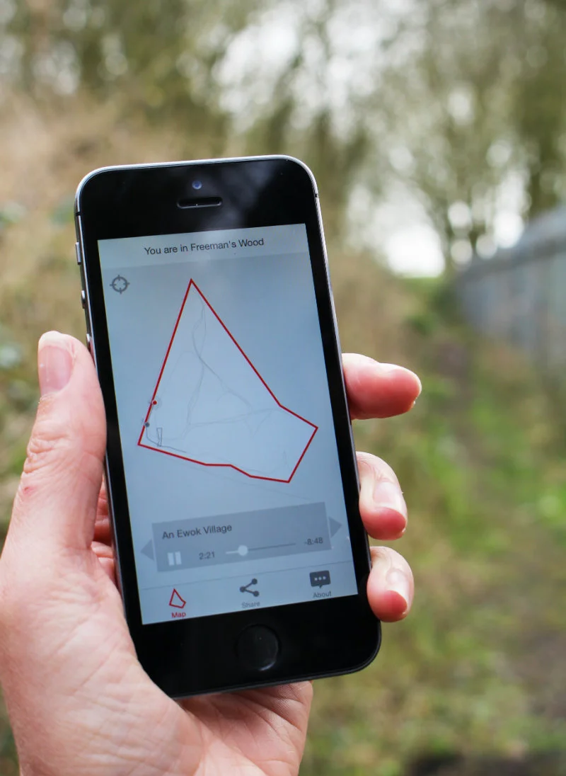
PHOTO: Sarah Sparkes
Freeman’s Wood is an urban edgeland on the outskirts of Lancaster, northern England. For decades local people have been using the wood for recreation, until it was recently closed off by its owners. The offshore private property company erected a metal fence, barring locals from entering, and threatening those that attempted to gain access to the wood with trespass laws.
In reaction to this, the artists Layla Curtis has developed an iPhone app that provides users with an oral history of Freeman’s Wood, via a series of interviews with members of the local community that she recorded whilst walking inside and outside of the wood. The interviews reflect on the impact and importance of this place on their lives, as well as speculations as to what the future holds, and the memories and insights create a series of moving narratives about boundaries and the shifting meaning of ownership and common land.
The key to the app is, however, that you need to be on those walking routes to access the stories. Once you are nearby the app uses geo-location to identify where you are in relation to the boundaries of the wood, and indicates the starting points for the thirteen walking routes. Crucially, to access all thirteen, you need to choose to trespass… across the fence and into Freeman’s Wood. We caught up with Layla to find out more about this fascinating project.
Listen to a sample from the app:
Can you tell us a little more about the origins of the idea?
I was invited by John Angus of StoreyG2 to visit Freeman’s Wood shortly after the steel security fence was erected around the site in 2012 by the current landowner (a property investment company registered in Bermuda who had recently begun the process of gaining planning permission to build on the plot). Members of the local community were investigating ways in which they could continue to legally use the land, protect it from potential development and bring it into public ownership. An application to register the land as a Town Green had been submitted to the local council, along with requests for three of the footpaths that crossed the space, to be officially recognised as Public Rights of Way. John had begun a research project about landownership and its effects on local people inspired by the situation at Freeman’s Wood and invited me to be part of it.
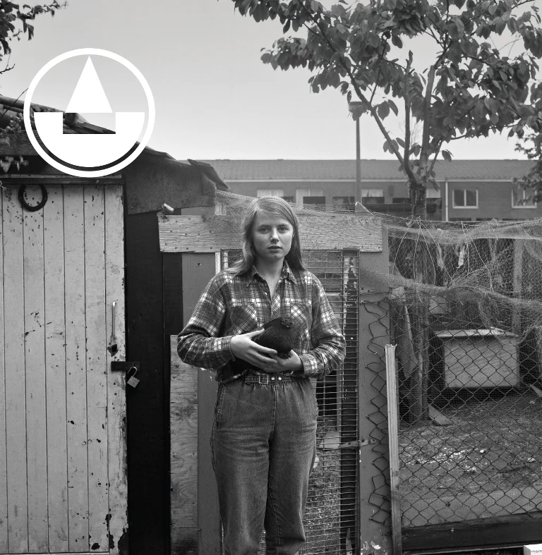
Freeman’s Wood is industrial wasteland, now partly overgrown with mature trees, gorse bushes and scrubland; it is a semi-rural, semi-suburban edgeland situated on the outskirts of Lancaster. I found the surrounding fence and the threatening ‘Keep Out‘ signs intimidating, however once inside I quickly warmed to the site itself. It was clear to me that this land was well used by local people, despite the restrictive intensions of the fence. At the time of my first visit a rope swing hung from a tree just inside the perimeter fence, elsewhere a den was visible deep in the undergrowth and there were BMX tyre tracks in the hardened mud of well-worn footpaths. I followed discreet arrows drawn on reflective ribbons tied to trees leading to a fire pit strewn with discarded empty beer cans and I imagined this place as an adventure playground where local children (and adults alike) could make and live by their own rules, escape and feel free.
It was evident that someone was fighting back against the installation of the fence – I noticed several of the palings had been removed creating gaps and allowing access. Many of the warning signs had been graffitied with political slogans about landownership – some had been cleverly manipulated to subvert their intended meaning; ‘WARNING: Keep Out – Private Property – No Trespassing’ became ‘NARNIA: Kop Out – Prat Proper – Try pissing’. This is a place of territorial tensions where the interests of a local community are colliding with those of global capital.
How did you find the stories?
The app contains thirteen audio tracks compiled from interviews I carried out with seventeen local people. The interviews took place in Freeman’s Wood, mostly inside the fenced off area. We discussed the land as we walked across it – the local people reflected on the impact the wood has had on their lives, and shared memories and personal accounts of how they have used the space for all kinds of recreational activities – bird-watching, foraging, cycling, dog-walking, den building and BMX biking are just a few examples. Some interviewees remember when the nearby linoleum factory was in use, and when the now-dismantled railway line, which cuts through the site, was still in operation. They discussed the landowner’s recent erection of the steel security fence and accompanying ‘Keep Out, No Trespassing’ signs, the emotional impact this had on the community, and how this has affected the way the space is now used and accessed. We talked about wider issues of landownership, trespass, territory, common land and activism, and speculated as to what the Wood’s future might be.
I mapped our walking routes through the Wood using GPS and plotted them onto the map in the app. Users of the app are invited to walk these same routes while listening to users of the Wood recount their experiences.
Why the limitation? What was the motivation for making the user commit the act of trespass in order to access the stories?
Trespass invites users to come to Freeman’s Wood in order that they can experience for themselves the place that is the focus of this work. Three of the app’s audio tracks can be listened to by anyone who has downloaded the app, however to unlock access to the other conversations, users must cross into the now fenced off area of Freeman’s Wood. On approaching the site users of the app are directly confronted by the physical presence of the fence and are therefore forced to consider the act of trespass. They must decide for themselves whether they will trespass the boundary to fully access the audio content (in the same way that local users are forced to decide whether they will trespass to access the land.)
While the presence of the fence and signs deter some long-term users of the Wood from crossing its threshold, there are several breaks in the fence and it is therefore a very easy boundary to cross. Despite the restrictions, well-worn footpaths still weave across the space.
Can you say something about the importance of place, or perhaps better space, to your work?
My practice focuses on the ways we perceive, navigate and make use of physical space and I am particularly concerned with how we map borders and boundaries, how we define territories and establish a sense of ‘place’. I was curious to meet the people who were suddenly labeled ‘trespassers’ for accessing land they had enjoyed for decades, and set out to investigate the impact the fence, and the actions of a property developer situated on the opposite side of the globe, was having on the local community.
Tell us a bit more about yourself? What are your main motivations as an artist?
My work has a focus on landscape, mapping, and the ways we locate ourselves, represent terrain and our movements through space. I am interested in the attempts we make to order the world, to chart it and the security that this brings; or rather the insecurity that results when we are unable to do so. Often I am seeking to understand place by examining its relationships with elsewhere - observing and revealing connections between locations which may not otherwise appear to have any obvious reason to be associated, such as two antipodal points on earth or those with shared place names.
So it is about the spaces we inhabit, how we define and map them, and differing cultural approaches to issues of land ownership, territory and access. I am interested in how architecture, space and the city can be subverted, re-claimed, re-imagined and re-experienced through practices such as psycho-geography, skateboarding, parkour and urban exploration /place-hacking - and how these practices (consciously or not) challenge the official demarcation of public verses private space.
I work with a variety of media: collaging maps to create fictional cartographical works; creating drawings compiled of text taken from atlases; and employing technologies such as thermal imaging cameras, mobile phone apps, Global Positioning Systems (GPS) and video to create drawings and trace journeys.
My research explores how contemporary navigational, tracking or surveillance technologies such as GPS, drones, geo-location, hidden cameras, and infra-red might be borrowed from use in military, recreational or scientific contexts and appropriated to seek alternative artistic solutions for representing terrain, our journeys across it and our interactions with it. Through this I am attempting to push the limitations of these technologies, exploring how they might be hijacked and used as tools for drawing.
Trespass was conceived and designed by Layla Curtis. The app was programmed by Ron Herrema. Trespass is available as a download via the Apple Store
For more from Layla - visit her website
Trespass was commissioned by StoreyG2 and is part of the project LANDED (Freeman's Wood), an exploration of the issue of land ownership, and its effects on people and places. Other commissioned artists are Goldin & Senneby, and Sans Façon. Find out more about the project on the StoreyG2 website.