Usedom: A winter diary

Usedom2.jpg

By Paul Scraton:

We have travelled north to the Baltic in the lowest of low seasons, to reflect on the passing of another year and another decade at a place that has meant so much to us over the recent and not-so-recent past. It feels like we are the only ones here, in our thatched house divided into apartments, and we move quietly up the stairs despite knowing there is no-one around to disturb. We arrive after dark, so we know our location only from the little blue spot on the map, but the morning will come and we will step out onto the village’s quiet streets, to walk from one side of the island to the other.

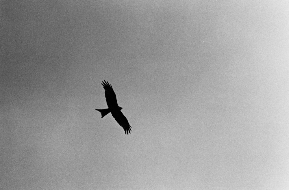
The next morning, when we reach the harbour the view across the inland sea is obscured by the mist that has rolled in off the Baltic and covered the island. Is there any point to this? We ask ourselves the question, but still we press on, following a farmer’s track across the field to the lookout point. It is a gesture more of hope than expectation, for visibility is down to less than fifty metres, but we are rewarded. First we hear the call, loud and distinctive, sounding through the mist. And then we spot it, standing tall in the misty field. A white-tailed eagle, its distinctive beak visible even in this strange half-light. After a moment it takes flight, and we catch a momentary glimpse of its impressive silhouette, before it disappears into the mist and the clouds, soaring high and out of sight. Perhaps it manages to get high enough for a glimpse of the sun. We can only imagine. 

It will be a day of shadowy apparitions, of figures emerging and retreating as we make the short walk that will lead us across the island from the lagoon to the sea. We leave the last of the village houses and enter a low landscape of fields, drained by ditches and surrounded by dykes, home to bulls, sheep and horses. In the distance, we spy a couple striding along a dyke-top path that my map tells me is a dead end. In the other direction, two cars meet at the end of a bumpy track beside a collection of tumbledown wooden buildings. I imagine a conversation through open windows and something in the boot, to be transferred from one car to the other.

You cannot help but summon scenes and images when the mist obscures almost everything that would normally be in sight. The footpath enters a forest, rising and falling between dense evergreen trees before we come across a brick house behind a high wall and metal gates. There are empty flagpoles in the garden, three of them, and they suggest a story, a history, that is unavailable to us in the mist. Unhappy is the land in need of heroes, and insecure is the land with too many flagpoles. But those poles were erected in a country that no longer exists, and however insecure we might be, not all of us are waving flags.  

Across the main road and the railway tracks, we enter the resort, where the houses sit on low cliffs above the beach and dunes, with a view across the stilled waters of the Baltic Sea. The kiosks and beer gardens are shuttered and closed, but smoke rises from the chimneys of holiday homes and light shines behind net curtains in some of the windows. In the distance the mist curls around the white towers of a grand hotel, that seems less grand the closer we get. The walls are water-stained and the terrace canopies tattered, with grass poking through cracks in the paving stones and a handwritten note posted in a smudged window to tell us the bar is closed for the season. 

In the 1920s this was the preserve of silent film stars, who travelled north from the studios of Berlin to take the water and the sea air. Now, at the start of the 2020s, the town was quiet, the posters outside the hotel advertising karaoke nights and tribute acts, and evenings with members of GDR-rock bands, the skeleton staff stalking the echoing halls in service of the handful of guests. 

Usedom3.jpg

We walk through the dunes, past an old fishing boat long out of service, and for the first time we see the waters of the Baltic. At the beach, the sand, sea and sky blend almost into one as ghostly figures walk the sands. In the mist it has been a kind of half-light all day, and now even that is fading. It is as if the town, the hotels, and the island itself is just waiting. The new year has begun. A new decade. But not here. Not yet. Only when the mist lifts, and the sun starts to shine once more.

***
Paul Scraton is the editor in chief of Elsewhere: A Journal of Place and the author of Ghosts on the Shore: Travels along Germany’s Baltic coast (Influx Press, 2017) as well as the Berlin novel Built on Sand (Influx Press, 2019). 

The Way(s)

IMG_1038.jpg

By Ashley Moore:

You are a fraud for entering the cathedral without hiking boots. A fraud for arriving without a sweat-stained backpack you haven’t been lugging along northern Spain’s Camino de Santiago for weeks on end. Nevermind that you recently put your own sweat and tears into 110 kilometers of the Peruvian Andes, or that you finished your first fourteener there at Abra Mariano Llamocca pass, or that you do not need a cathedral at the end of the journey to know that these long-term treks are their own type of religion, one that relies on a fanatical belief in your own two feet: no horses, no mopeds, no cheating. You will recognize the all-too-familiar zealotry of the wanderers as your own, but in Santiago you still feel like a day-tripper, a fraud.

You know the stories of The Way secondhand, some of them from the plane ride in. How modern-day pilgrims begin the trek solo only to form impromptu families that are just as quickly dissolved when hikers decide on their own pace, their own personal Caminos. The camaraderie in the communal songs sung as payment for dinners at the low-cost albergues many trekkers overnight in, how these same people may never encounter each other again. The time and space that the walking provides, the transformative, even spiritual, effect of the voyage on religious and non-religious pilgrims alike. You feel the energy pulsing beneath their fluorescent-colored all-weather outdoor gear, the triumph of the body and mind over the weeks of walking, a mixture of joy and sadness that the journey has been completed, but is also at an end, as they make their way to the final stop of the trek: the Cathedral of Santiago of Compostela.

From the outside, the cathedral feels tiredly familiar. There is a part of you, having seen so many of these, that has bored of this mixture of architectural styles, the ages of renovations running into and over each other, the 11th century Romanesque and the 18th century Baroque, the masterfully crafted yet predictable stone reliefs of Biblical scenes adorning nearly every surface of the structure’s façade. Inside, you expect more of the same. 

Maybe it’s the way the light changes as you move out of the sun and into shadows, which are only ruffled by the flicker of dozens of candles and the smoky incense wafting from some unknown source— the nearly two-meter tall, gold-sheened Botafumeiro hanging unused above the altar. Maybe it’s all the tragedy, that emaciated Jesus, limp upon the cross, an especially foreboding skull staring directly at you from beneath his punctured feet. Or perhaps it’s the knowledge that at this very moment, you are looking at the silver case in the underground crypt that holds the bones of St. James. 

Here, deep inside the cathedral, you and the brightly-colored pilgrims are all frauds. This place belongs to the true believers, whose energy seems to puncture and slice through the gloom. Theirs are not the glad smiles of the hikers, but the fervent conviction of bent knees on stone floors, of clasped hands held so tightly against bent heads that it almost seems as if you can see the blood beating through the wrist veins. 

An instinctual urge to join them comes suddenly, unbeckoned, with the speed of a tsunami. A natural disaster that cannot be predicted or charted like a hurricane, one that has no tornado season or government-installed alarms. The kind of thing that comes from a deep upheaval of earth and rock and water producing a wave, 20-meters high, threatening to smash into you and all these years of agnostic exile. 

You stand there too long— not transfixed in awe, but immobilized by the shock. 

You leave the crypt but not the feeling. Near the altar, you find walls covered in washed-out medieval scenes of horses, scallop shells, and eight-sided stars. The faded blue and red hues complement the 3-D geometry of the marble floors. You reach out to touch the cream-colored shells painted onto those walls, the same shells that pilgrims have gathered along the Galician coast for centuries as proof of their completion of The Way. You pull your hand back before you can disturb the art and turn, only to find Christ – dead again on the cross – and another Christ – still dead – in the arms of Mary and his disciples. Amid the gold and the marble and the lacquer that turns his face pallid and frail, Jesus always seems to be already extinguished here. 

You finally begin to come back to yourself. No living God could ever call this place home, his love abandoned by his people, no apologies for the burnt stakes or bombed hills, the altar boys or unwed Oklahoma girls secreted off to abortion clinics in order to be married in white, the “rehabilitation” of same-sex attraction. God was forced out of this place a long time ago. All that remains here are the red robes and starched white shirts of the men who ran him out. Them and their relics: the kneecaps and femurs and severed heads of saints and apostles. All the church’s evidence, stamped and approved by its own authorities. An autohistory on repeat, slowly calcifying under the pressure of time into something that they can call proof. 

You do not want their evidence. You want to join the believers, to feel the conviction of your youth. You want to kneel. It’s an ache, a fundamental need to know the communion with God you once felt in prayer, that otherworldly plane of being you’ve only ever been able to replicate in meditation. You want to believe not just in that God of your youth, but in the only living things in this place: his people. 

Garish gold angels look down on you from the altar. More smoke hovers near the winged pipes of the organ, the Botafumeiro impotently hanging, so heavy and so high. The candles, you notice, are all electric, activated by slipping coins into slots, as if this were an arcade. Behind them, the severed saints’ heads are hidden away in gold-sheened boxes, kept behind intricately-designed bronze bars, in the shadows, off-limits, and, for all you know, long-ago turned to no more than dust in their beautiful encasings. 

You won’t kneel, but you still talk to him, unconsciously, the way you’ve always talked— like old friends, apologizing for the time it’s taken to get back in touch. You tell him it’s been so long that it’s almost like he doesn’t exist. You ask him where he went, why he didn’t call. You probably cuss at him, and then apologize for cussing, and then thank him for forgiving the cussing and the doubt. You tell him you’ve missed him, that it hurts to see him there – it always hurts to see him there – all locked up in the stones they’ve carved him into, bleeding in eternal enameled submission to their image of him. 

You know it’s unlikely and that there may well be a special circle of hell for this kind of thing, but you still ask him to come with you, wherever he is. You want the pilgrims to find him living in the sunsets along the Camino, the same way you thought you saw him in that baby sheep that wouldn’t stop following you outside of Yanama as you made your way up that 5000-meter pass in the Andes, in the few minutes that Salkantay’s peak broke free of the cloud cover at the exact moment you made it to the top. You want him to live in the impromptu harmonies of the pilgrims’ amateur songs, in the urge they have to sit a few days out, to stay in one place for long enough to sing new harmonies and form new families. You want him to be found along all of The Ways.

Outside, you are relieved by the brightness of the sunlight and the glad chaos of the fluorescent-tinged tourism. In the large, flat square that opens out before you, cameras click and selfie sticks abound. You rejoin the wanderers, none of you frauds. You take your own photos of 11th-century doorways so short that they only come to your shoulders and notice that the large, centuries-old stones at your feet seem to be opening out as the waters and winds of time work them over. There, among the gaps, are the modern-day bronze versions of the ancient seashells that have marked the Camino’s path for everyone who’s ever walked this way. At the windows of the cathedral, and even along the walls, young green leaves seem to burst right out of the stone. Maybe someday they will be bushes or trees. You wonder how they managed to sprout there, how deep their roots can go before the marble starts to crack. You wonder how long they will be allowed to grow. 

***

Originally from Oklahoma, Ashley Moore is a writer, editor, and educator based in Bayreuth and Berlin. She is a fiction editor at SAND literary journal and teaches at the University of Bayreuth. Her flash fiction was chosen for Wigleaf's Top 50 Very Short Fictions of 2018 (selected by Manuel Gonzales), and her other prose can be found in The Rumpus, Hobart, Monkeybicycle, and other publications.

Life and Death and the Walls of Weetabix: A walk up Glasgow's High Street

IMG_9914.jpg

By James Carson:

It’s best to stop at the lights. With traffic coming from all directions, the slightest trip could put me in hospital. But it’s too long a wait for one young lad, who strikes out for the other side, ignoring the blitz of angry beeps. Beside me, a baldy bloke with hairy ears glares at the youngster, who’s now happily powering up High Street.

“Obviously trying to make a statement,” he says, eyebrows twitching. “And the statement is he’s a dickhead.”

I’m at Glasgow Cross, once the bustling centre of a medieval burgh. Today, the fish and cloth traders of old are long gone, replaced by pubs and pawnbrokers, chip shops and bookies. 

It’s the last day of winter. Tonight, the golden hands on the face of the old tolbooth clock tower will be wound forward into British Summer Time. As ever, Mother Nature is one step ahead. This afternoon, Glasgow is wearing her spring collection: a cloak of yellow sunlight, with matching cerulean sky, accessorised by feathery white clouds.

To the south of Glasgow Cross lie Saltmarket and the River Clyde; to the east is Glasgow Green – the city’s oldest park. And westward is Argyle Street, a place of pilgrimage for those who worship at the church of St Marks (and Spencer). But today I’m heading north, up High Street. It’s a road well-travelled; I often use it as a shortcut when I’m in a hurry. Today I’m taking my time.

The 120-foot clock tower at Glasgow Cross was once attached to the tolbooth, a multipurpose building whose functions included town hall, jail and reading room. Perhaps most importantly, the tolbooth was a gathering place, a stage for the mercantile glitterati to see and be seen. It was built in 1626, the same year as the finishing touches were being put to the new St Peter’s Basilica in Rome. But while St Peter’s endures, Glasgow’s tolbooth was demolished in the 1920s, one of many fine buildings the city fathers have sacrificed to the wrecking ball. Only the slender clock tower remains, marooned on its own little island as Glasgow flows around it.

History is in the stones of this quarter, and in the street names: Brunswick Street recalls the House of Hanover; Blackfriars Street is named after an order of Dominican priests who founded a church near here in 1248.

High Street gets its name from the High Kirk, better known today as Glasgow Cathedral, which crowns the top of the street. If this were Bordeaux, say, or Zagreb, this quarter would be known as ‘The Old Town’, with quirky little shops selling vegan shortbread, clock tower fridge magnets and inflatable kilts made in China. There would be restaurants with buxom wenches in authentic medieval smocks, serving authentic medieval haggis. A historical tramcar would jangle its way up and down the street, ferrying tourists from Baltimore and Brisbane. 

On the lower reaches of High Street, the vibe is very different from this imagined world. People are doing Saturday afternoon things: football fans on their way to the match, students brunching on sausage rolls. There’s a Turkish restaurant (“opening soon”), a pub (closed), a charity shop (closed down), a bedding store, another pub, student flats and another pub.

Actually, not just another pub. A sign outside declares it to be Glasgow’s oldest, dating from 1515. This is a bit of creative PR on the part of the owner. The bar actually dates from the 19th century, although its shabby appearance wouldn’t look out of place in The Flintstones.

The pub may be nothing to look at, but its neighbour is a real beauty. With a two-storey step gable and a gorgeous little domed canopy (a tempietto, if you please), the former British Linen Bank building is like an exotic fusion of Amsterdam townhouse and Mughal temple. It stands now in solitary confinement, badly in need of some TLC.

In fact, this whole stretch of High Street feels rundown, although little shops are doing their best to cheer things up (“The Best Steak Pie in Glasgow!”). It’s possible that Billy Connolly was thinking of this very spot when he once mused that if a nuclear bomb ever fell on Glasgow, no-one would notice the difference afterwards. Since the Big Yin made that observation, much of the centre of Glasgow has been given a makeover, morphing from industrial relic to Barcelona of the north. Decades of grime were removed from civic buildings and a constellation of starchitects sprinkled the city with their fairy dust.

It’s been an impressive transition, and Glasgow has somehow managed to achieve it while retaining its essential character. It’s a city that can celebrate the great works by Van Gogh and Dali displayed in its galleries, while simultaneously applauding the artistic genius who used the medium of spray paint to declare that “Boris Johnson is a pure fanny.”

The final section of High Street curves round towards Cathedral Square. There are lots of empty properties here, but also a cluster of new-age businesses, dispensing everything from aromatherapy to tarot card readings. And there’s an off-licence, so if the cards say your future’s not looking rosy, you can quickly hit the rosé.

Above the shops, sturdy tenements in red sandstone lend an air of dignity to the street. If Toulouse is La Ville Rose, and Aberdeen is the Granite City, then Glasgow is simply red. The russet colour features strongly in tenements all over the city. They’re made from an iron-rich building material that dates back nearly 300 million years, when Scotland was covered by a vast desert. The same colour can be seen today in the sands of the Sahara that are sometimes carried by dust storms to fall on Glasgow as ‘blood rain’.

The vision of Glasgow Cathedral at the top of High Street is an uplifting moment. It was built between the 12th and 15th centuries, and is the only mainland Scottish cathedral to have survived the Reformation intact. The interior has soaring gothic arches and sublime stained glass. Below, the tomb of Glasgow’s sixth century founder, St Mungo, underlines its historical resonance. When it was completed, Pope Nicholas V declared that a pilgrimage to Glasgow Cathedral was the equal of one to Rome. It’s fabulously beautiful. 

Across the square, the Museum of Religious Life and Art is less so. Opened in 1993, it was intended to blend in with its venerable surroundings, but doesn’t quite get there. The exterior walls seem to have been crafted from breakfast cereal (it’s known locally as Fort Weetabix), and there’s a Disneyfied attempt at a bishop’s castle. The whole effect is less medieval masterpiece, more product of the muddle ages. I could spend the rest of the afternoon exploring its exhibits, but I’m enjoying the warmth of the sun on my face. It’s time to walk among the dead.

Glasgow’s Necropolis occupies a hill overlooking the cathedral, with panoramic views across the city. I feel at peace among the tended plots, but I’m not alone. The place is teeming with tombstone tourists, with voices from France and Germany, Poland and America.

Here, every stone tells a story; different circumstances, but always the same ending. Death at war, at sea, and all too often, in childbirth. Most of the permanent residents here are from well-heeled Victorian and Edwardian families – merchants and magnates, aristocrats and knights of the realm. But there are surprises, too: a Polish freedom fighter, the matriarch of a Gypsy dynasty; the first woman to graduate in medicine from Glasgow University. Even in a graveyard as grand as this, there are no answers to existential questions. Only an eternal verity: life goes on until, at some point, it doesn’t.

From up here, I can retrace my afternoon walk. I’ve only covered about half a mile, but I’ve reached across the centuries. It was the medieval High Street that nourished the relationship between the cathedral’s community at one end and the market traders at the other. Which is why, for all its faults, this stretch of land retains a special place in the city’s history and heart: no High Street, no Glasgow.

***

James Carson is a writer from Glasgow. His work has appeared in various magazines, including From Glasgow to Saturn, The Skinny and ExBerliner, and his stories have also been selected for anthologies such as Streets of Berlin, Tip Tap Flat and A Sense of Place.

The Graffiti Chapel

IMG_3288.jpg

By David Lewis:

Some days we could walk across the city without touching the ground.  In the 1960s, when the city was welcoming the car into her widened streets with open arms, it was decided to extend safe sky-streets over the busy roads.  We called them the walkways. Bridges sprang over the traffic and the walkways connected them. By the time I knew them twenty years later they were filthy and vandalised but still connected parts of the city centre, like a half-cleared railway network of odd branches and unused lines. 

So the city decided that the walkways had been a mistake, and decommissioned them.  Gently they were cleaned from the city’s streets and perhaps her memory as well. The scars are still there, brick or concrete rectangles on the first floor of buildings where a walkway used to be, the stumps of bridge supports, another scar-rectangle matching on the other side of the road. 

When I knew they were going to demolish them, I walked as many walkways as I could.  They leaped across Old Hall Street, Roe Street, the Goree, others I cannot remember, so familiar were they and so completely have they been erased from the cityscape.  The walkways squeezed between buildings to create sky-streets of broken lights and urine. And graffiti. Inevitably the taggers and street artists saw the walkways as a golden opportunity to enrich the city and the urban experience.  

Two walkways met at a small open pavilion, a room open on three sides to the elements, the roof supported on slender concrete pillars.  Every inch of the walls and ceiling and floors was spray-painted, and over-painted, and painted again. Names and titles and challenges and dates chased each other over the concrete in a swirl of reds and silvers, blacks and yellows, blues and a rich strain of orange. Standing there, I lost all sense of proportion or depth, as if in a chapel by Giotto, a street trompe-l’oeil, vertiginous and disorienting.  It smelled of cigarette smoke and urine rather than frankincense, and unlike Giotto the artists had no need to respect perspective, morality or architecture, but they were liberated by their concrete canvas: the words and colours flowed freely over floor and wall, onto windowsill and pillar, swirling to head height and beyond, so that the floor seemed to descend and the ceiling to rise into the sky.  It was bawdy, exciting, psychedelic, exhausting.  

And it was doomed.  The cigarette smoke was the problem.  The graffiti chapel stood like a debauched and drunken priest alongside the new solemn fortress of the Crown Courts on Derby Square, a reminder of the anarchic city, the lawless city, its underbelly, everything the towers of the Courts stood against. The Courts were built in a deliberate biscuit-concrete echo of the Castle that once stood there, and Crown Courts and graffiti chapel stood like a debased version of what used to be, Castle and Church. 

The graffiti chapel and the walkway was where the visitors to the Crown Courts, the families and friends of accused or plaintiff, stood for an anxious cigarette, and the smaller messages were prayers of hope, votive offerings to an indifferent Law; ‘Thomas is Innocent!’ ‘Luke S Got Five Years Should Have Been Ten’, ‘Where’s the Justice for Our Mary’.  Painting the walls would only attract the graffiti boys again, and it was decided to demolish. So one autumn day, tracing surviving walkways or their routes on the ground, I turned a corner to find the graffiti chapel gone. In my days writing about the city’s churches, I turned other corners to find other chapels demolished, but none saddened me as much. 

***

David Lewis has written five books of history/landscape/psychogeography about his native Liverpool and Merseyside.  He posts urban/rural images on Instagram - davidlewis4168 and mutters about the world on Twitter - @dlewiswriter


Mirages: A walk along the periphery

Holkham Beach.jpg

By Julia Bennett:

mirage noun 1. an optical illusion caused by atmospheric conditions

Air still, heat building during the morning in the summer of 2018. Purple marshes to the right, tinged with sea lavender, to the left the creeks and sandbanks of the interstitial area between land and sea. Stepping out eastwards from Burnham Deepdale, the North Norfolk coast path crosses Deepdale Marsh on a high raised bank. Upturned boats seemingly abandoned to the mud and gulls; a windmill in the distance, unmoving. A sense of desolation averted by the Mediterranean-like heat. A group of paddle boarders drift past: serenely balanced on their boards in the still waters of the English coastal creeks, but clearly not fit craft for the rigours of the North Sea crossing itself. This is the not-quite-land and not-quite-sea border of the rump of England, back turned towards mainland Europe out across the North Sea.

The path itself, built up above the tides, steers a tenuous path between the opposing forces of land and water. The local population of sea birds is well adapted to the equivocal nature of this place: long-legged orange-beaked oyster catchers; a lively assortment of gulls; mousy-brown curlews, elongated toes splayed over the surface, long bills digging deep into the salty mud. Passport-less, curlews travel across Europe. Some stay in the UK over winter, others choosing France or Spain, like elderly British holiday makers spending a few months somewhere warm to save on heating bills. A slight ripple in the creek signals the presence of those bilingual, multi-modal, land-and-marine mammals: an otter, bobbing a furry head briefly above the water. For millennia the North Sea has provided a pathway to the rest of the world, rather than a moat around the castle of England.

Hitting the road at Burnham Overy Staithe the mood changes: the harbour bustles with tourists, boats clamouring for their custom. Zig-zagging through the crowds, the coast path steps out again onto a high bank, this time crowded with people headed to the beaches at Holkam Nature Reserve. Creeks and channels curl into the spit of land like tree roots digging into a rock face, refusing to give way to the clarity of either land or sea. Dunes ahead obscure the view of the beach whilst simultaneously signalling its sandy closeness. Over the dune-summit the land finally concedes defeat and in a long exhalation of breath sends a broad expanse of blue to meet the horizon. Golden sands stretch eastwards as far as the eye can see, a broad yellow-highlighter mark on the map demarcating the island of Great Britain from the continental mainland. Walking now along the shoreline footprints stamp out tribal belongings, temporary tattoos washed away by the next wave. The hot, still land seems to hold its breath and wait. Gradually, Holkam beach broadens out as the land of this corner of England distinguishes itself from the polyglot North/Nord Sea/see/zee. No longer a liminal space between land and sea, mainland and island, the ground underfoot becomes a little firmer and the atmosphere changes.

mirage noun 1.1. An unrealistic hope or wish that cannot be achieved

A couple of miles along, dunes rise again and behind them, a cool, sweet smelling pine wood reminiscent of the beaches of Northern France. The cool silence of the deserted sand-and-pine-needles paths sheltering beneath the trees provides a breathing space away from the spotlight of the hot midday sun. Through the trees, glimpses of colourful painted beach huts presage the arrival of the superior-but-faded grandeur of Wells-next-the-sea. In bright blocks of colour or Breton stripes beach huts are a staple of the traditional British seaside, along with buckets and spades and sticks of rock. But unlike the cheap plastic buckets on sale they are highly desired properties, costing almost a day’s wages to rent for the day, despite being, literally, built on sand.

Emerging from the trees the path skirts a large car park before following the sea wall into Wells-next-the-sea, ironically another mile inland due to the retreat of the sea over the centuries. A mini-train transports those without cars to and from the beach. The sea’s retreat changed the identity of this place. Wells was a busy trading port with Europe in the sixteenth century but is now a slightly upmarket, English seaside town with fish and chips and tacky souvenir shops along the front and a few olde gifte shoppes in the narrow roads heading inland.

The coastal bus service passes through here. It is full of school children at 4 o’clock on a term-time weekday afternoon, with a few tourists and the occasional local. Along this gentrified stretch of coast, the bus travels through picture-postcard villages: red-tiled rooves and Georgian facades, roses around the doors of stone cottages, traditional butchers’ and greengrocers’ shops with names written in antiquated fonts, and the ever-present bunting, flapping gently in the breeze. At first glance this is an image of a corner of England which, much like Wells, has been left high and dry by the twenty-first century. A Disneyfied mirage, hazy in the late-afternoon heat. Isn’t that a ‘Jack Wills’ nestling amongst the tea shops of Burnham Market?

***

Note: Definitions taken from en.oxforddictionaries.com

Julia Bennett is a sociologist who researches place and belonging


An Autumn Sunday afternoon walk around Rawhead

Rawhead_Julia.jpg

By Julia Bennett

Driving eastwards past the 150 year old mining engine house chimney - a lieu de mémoire for the dark dirty-secret past of this green and pleasant corner of England. This is the old Salt Road. Salt was carried from the Cheshire 'witches', the towns of Middlewich, Nantwich and Northwich, to the port at Chester, and later Liverpool, to trade with Africa and Asia. Up the steep Coppermine Lane to reach the top of the ridge. Squeezing in amongst a crowd of Sunday cars on the side of the road.

The path heads off. A stony farm road leading first west and then south towards Whitchurch. This is the Sandstone Trail tracing the sandstone ridge along the western side of Cheshire for 55 kilometres.

The potholed track soon dissolves into a footpath. Skirting the edge of the steep wooded hillside:

silver birch leaves burnished gold;

blood red rowan berries;

prickly sweet chestnut tempting hungry squirrels.

Trees frame distant views:

north across the Mersey, the solid square-built sandstone tower of Liverpool’s Anglican cathedral; closer, a cluster of slim flame-topped stacks pinpoint the oil refineries at Ellesmere Port. Closer still the Roman City of Chester hunkers down on the banks of the river Dee all but hidden in the folds of gentle rolling green pasture, that most English of English landscapes extending to the very edges of the country before drowning in the waters of the Dee.

… black rooks somersaulting against the blue-grey sky …

Across the fields to the east, beyond the giant white saucers of Jodrell Bank, the hazy beginnings of the Pennines.

… pinky-brown chaffinches flash white stripes as they flit from bush to bush …

The path narrowly clings to the edge of the soft, red sandstone cliffs. Cliffs formed during the Triassic period 250 million years ago, says the information board, once upon a time, a long, long time ago.

Not so very long ago, in the 1220s, Beeston Castle was built on a rocky outcrop, here in bas relief against the sky, a five kilometre walk north on the trail. Once upon another time it was the site of one of the Iron Age hillforts strung out along the ridge like a ‘join the dots’ guide to life here 3,000 years ago. . . . the trail following in ancient footsteps.

Steps lead down the side of the hill to a wooden platform. This is Dropping-stone well. Local people climbed up here to fetch drinking water as recently as the Second World War. In the not so distant past servants took sand from the caves which pockmark the soft sandstone to use on stable floors and as a scouring aid in the kitchens of the ‘big houses’. This was a busy, productive place, and not only on Sunday afternoons.

Rawhead itself, the trig point and the highest part of the Sandstone Trail stands at 227 metres. Rocks jutting above the trees, there are clear views from here. Over the border into Wales, Wrecsam’s industrial estate stands out against a background of the Clwydian Hills. Shropshire to the south and on a (very) clear day a faint outline of the Wrekin about 30 miles away.

The path turns southwards, continuing to snake along the very edge of the steep cliffs. Careful footsteps are needed to avoid sliding over the edge into the canopy of silver birch and scots pine that cloak the sides of the cliffs. Black holes mark caves in the rock faces.

A turn to the east. Rhododendrons flood a steep valley. A dull green for much of the year, in spring this ‘alien species’ large purple flowers are a prelude to the native purple heathers and plump ripening bilberries yet to come.

A small wood of scots pine, a cluster of farm buildings, the path runs next to a field separated by an electric fence. Noises off:

in the spring a cuckoo;

summer occasionally brings the insistent tapping of woodpeckers;

autumn, the rustling of pheasants in the maize stalks;

crows and farm dogs scrap and shout for attention all year round.

Down towards the kissing gate and the farm track. The Sandstone Trail turns towards the main road and southwards to Bickerton Hill. The sign to the Bickerton Poacher points left. This path follows behind the line of the fields and houses which border the main road. Overhung with stray fruit trees, damsons and crab apples tempt those walking beneath.

Crossing the muddy stream at the lowest point of the path, then uphill again past the memory of the industrial past: the brick chimney above Gallantry Bank.

Buzzards haunt the tall scots pines edging an open field, swooping ghostly shadows a prelude to their loud territorial claims. Shooting parties gather in this space. Gallantry is an elision of ‘gallows tree’. Hiding history in plain sight.

Over the stile and a steep climb up Coppermine Lane brings us back to the present.

Julia Bennett is a sociologist with an interest in place and belonging. She has lived in this part of Cheshire for 16 years.

Beacon Bound, Part I: The Collapse

Kite 1.jpg

In memory of his grandfather, Nicholas Herrmann walks the length of The Ridgeway: an ancient road stretching for eighty-seven miles across chalk downland, from Overton Hill to Ivinghoe Beacon. We will be following Nicholas’ journey here on the Elsewhere blog over the next couple of months.

When a star dies, the collapse creates an event of such immense gravitational force, matter is compelled from far and wide, and all light is extinguished. That point in space, once brilliant and warm, turns impossibly dark.

This is the image I have in my mind on the day my grandfather dies. The family is gathering at the house, and I’m speeding eastward on my way to say goodbye. The twenty-year-old car rattles and shakes, struggling to do seventy, and as I wedge the drooping window with an elbow, I remember from whom the car was inherited.

The red kite signifies the beginning of the Chilterns. Usually, its presence is comforting, telling me I’m close to my childhood home. On the M4, they appear around Newbury, their distinctive shapes patrolling the skies at the limits of some invisible boundary. I see one now, urging me on like a herald, soaring on an updraft as it leads me towards the tragedy.

Several hard hours later, we fill the house with memories. His gentleness, his mischief and decorum, his astounding knowledge of the natural world. The January sun shines a cold light onto dregs of Earl Grey. With energy left only to sit still, my father speaks an idea into the silence: he will walk the length of the Ridgeway – that ancient track that John, my grandfather, loved, and lived beside for much of his life. Eighty-seven miles from Overton Hill in Wiltshire, northeast along the North Wessex Downs and Chiltern Hills, to Buckinghamshire’s Ivinghoe Beacon. Britain’s oldest road.

There is unanimous support for the idea. A plan is quickly formed and agreed upon: my father and I will walk the route in stages, others joining us whenever they are able. We rise to leave. As I pull on my coat, a Post-it catches in the corner of my eye – something destabilising, at once familiar and strange. A small reminder, of something done or undone, written by someone else in my own handwriting. Another inheritance.

*

We start on Good Friday. As we load our packs into the car, a pair of red kites fly out from their nest in a nearby beech tree and circle us. Their call: half whistle, half screech, steady like a kettle on a camping stove. They fly low, their kiln-coloured breasts almost skimming the chimney. We stop and watch in the light rain, able to make out every mark on their speckled chests, every feather on their ashen heads. Red, white, yellow, black: all the colours of heat. Like winged devils they twist their singed wingtips and flick their forked tails. Then they pitch and roll away together over the fields, two embers drifting on the wind.

Kite 2.jpg

Scavengers, survivors, masters of extinction. As they once did in medieval times, kites fill the sky above Reading. At any given time, you can look up and see two or three of these raptors stalking the suburbs. But in the 1930s, after decades of persecution, just one or two pairs remained in the UK. Now, Britain acts as a lifeboat for the species – there are thought to be around 2,700 breeding pairs after a 1989 reintroduction in the Chilterns. And their numbers in Reading are on the rise. A study from 2015 found over four percent of households purposefully leave out meat for the birds, causing hundreds to commute into town each day from the surrounding countryside.

Avebury stone circle lies a mile and a half away from the start of our journey, so we make a stop to remind ourselves of its might and mystery. A crow lands on a megalith, oblivious, or uncaring. I place a palm on a pockmarked, rain-slick stone twice my height, its purpose lost to the ages. We make our way south, circle Silbury Hill – cumbersome and impenetrable – and pass the West Kennet Long Barrow, haunting us from a hilltop. The beginning of the Ridgeway is a car park that sits beside three squat tumuli, too regular on this topography to be given names.

This place undermines time. Prehistory and present congeal like the rain-churned paths orbiting Avebury, a thousand footsteps preserved in mud.

The Ridgeway National Trail was opened in 1973, and is just a section of a five-thousand-year-old route that used to run from the Dorset coast all the way to the Wash in Norfolk. In prehistoric times, the plains and lowlands were heavily forested and covered in undergrowth, making progress near impossible. The chalk provided a way through, drier underfoot, less impeded by vegetation. The trail we know today comprises two different ancient highways stretching across five counties and divided neatly by the Thames – the Ridgeway to the west, the Icknield Way to the east.

Sarsen.jpg

I step over the threshold. The chalk track stretches out in front of me, a steady incline of white on green, clinging to the contours of the Marlborough Downs. Stuck between seasons, the landscape sags under the accumulated weight of the rain, the track transformed to a gritty paste beneath me. To our right, woody tangles of hazel, gorse and hawthorn. To our left, fields curve down to villages and farms safely tucked into the combes below. Everywhere, we pass the sleeping noble dead, their resting places marked by clumps of beech dotted across the undulating landscape.

It’s quiet on the ridge. The weather is deadening, driving wildlife to its shelters. We pass rook nests and badger setts, unreachable and dark. I imagine these creatures in their sanctuaries watching our progress along the hills, as they have done for millennia. A solitary skylark punctures the hush, jostled by the wind. A hare takes flight. I step off the track onto the furrowed edge of a field. Shards of flint mark its perimeter, newly banished by the plough. I am hunting for axeheads and arrowheads, as I was taught to, by John. I slow my pace, using my feet to nudge and lift stones from the soil, hoping to unearth an artefact – coins, pottery, a clay pipe – just as he would while walking these hills.

Sarsen stones – those huge, mystical sandstone blocks used to construct Avebury and Stonehenge – litter our surroundings, increasing in number as we approach Fyefield Down. In this area alone, there are said to be 25,000. They are called the Grey Wethers, resembling sheep from a distance, but to me they just look like stones: inert, lopsided and lichenous, strewn across the hillside by a geological cataclysm. We press on, past four White Park cows sheltering from the easterly wind behind a gorse bush. Charming and ancient, with long, perfect horns, they turn to watch us through barbed wire.

White Park.jpg

Soon, we enter a section flanked on either side by shivering hawthorns, dense vegetation climbing their trunks as if the ground is rising to claim them. I pause in a puddle, confounded. As I consider the trees I become agitated, realising I don’t understand the process taking place. I don’t know if the growth on the trunks is moss, or lichen, or liverwort – if it’s harming the trees, or killing them, or benefitting both sides.

I don’t belong. I am out of place – a vagrant, a product of the city, a non-native species in a foreign land.

What am I doing out here, so exposed, so far away?

This is John’s world, not mine. He had a passion for moss and lichen, collecting them on walks, filing them with labels carefully away in a miniature chest of drawers. The photograph at his memorial is a portrait of John kneeling in a wood somewhere, studying the undergrowth, excited by a find. He would have understood this. He would have been able to explain it to me.

Further along, the track levels out, an alley of breeze-bent trees winding past a dew pond. Above, a kestrel is suspended against the clouds, feathers fanned and tousled. From a great height it scrutinises the hedgerows, before yawing behind the ridge and out of sight.

Rock pools.jpg

The landscape is an infinite pallet of earth – every imaginable shade of green and brown: grass, moss, leaf, thorn, footpath, fence post, bark and branch, soil, flint, chalk. Puddles like rock pools stretch across the width of the track and lead the way to a metalled B-road that spills down the hillside towards the village of Broad Hinton. Then, another car park – an island of discarded energy drinks and weathered Walkers multipacks. After hours on the ancient track, these objects feel uncanny and unwelcome. We stop by a log in a nearby copse for lukewarm coffee, and cheese and pickle sandwiches made soggy by the rain.

The sun fails to punch a hole through the sarsen sky. The wind picks up and the way gets muddier leading up towards Barbury Castle – the site of an Iron Age hillfort rising above the landscape, imposing even now after 2,500 years. It blocks the way ahead, the path climbing and cutting straight through. It’s in the ideal position – it has an eye on us long before we reach it, and its steep sides slow our progress. From the top I can see for miles to the west, surrounded by sheep grazing in deep ditches formed by the castle’s earthwork ramparts. And somewhere above, the radio told us, a Chinese space station is tearing up and hurtling down towards Earth.

The breath is blown from our bodies as we step onto Smeathe’s Ridge. Like a backbone holding together the land, the ground falls away on either side to the awesome expanse of the country. We follow the narrow ridge past plantations of oxidised larch and fields below, chalk showing through the dark topsoil in waves. At last unimpeded, the wind harries and hounds us, lashes the cold rain and numbs our cheeks. With a kite’s-eye view, I glide over the land, and I am overcome.

Our boots touch Tarmac, and we’re received by the sleepy environs of Ogbourne St. George, the first ten miles behind us. The rain swells the town’s little river, submerges great sections of road. We return home in a daze, our minds still on the hills. Clay-stained, we gather ourselves by the fire. It has been a day of elements.

That night I slip and slide in dreams of falling.

The journey has begun.

Nicholas Herrmann is a writer and photographer based in Bath. His work has appeared in journals and online, and his writing has been shortlisted for the Bath Novel Award and Janklow and Nesbit Prize. He is a graduate of the Creative Writing MA at Bath Spa University. He is currently working on his first novel. You can find him on Twitter: @NickPSH.